Find Your Daily Voice
 44°
44°
After The Storm: Bitter Cold For Christmas Eve, Xmas Day Before Big Change In Weather Pattern
Let's hope Santa Claus is wearing an extra pair -- or two -- of long johns.
That's because Christmas Eve and Christmas Day will be the coldest in decades.
A powerful, massive storm that brought a mix of heavy rain, damaging winds, sleet, and snow, has now moved off the coast, but the passage of a cold front accompanying the system has led to a dramatic dip in temperatures.
The wind-chill factor on Christmas Eve on Saturday morning, Dec. 24 is below zero degrees in most of the region.
After a sunny start, clouds will increase during the day, but the high temperature will only be in the mid…
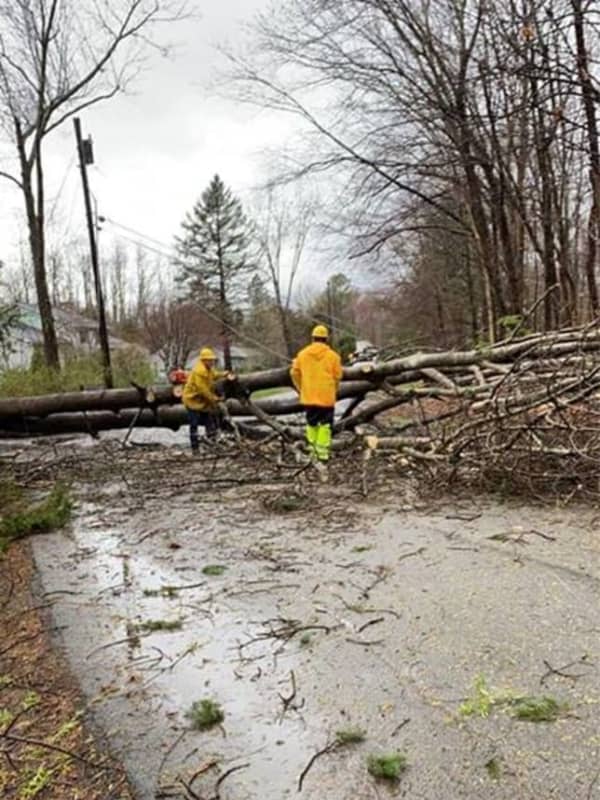
Storm Knocks Out Power To More Than 100,000 In Hudson Valley
A powerful storm system bringing heavy downpours and damaging winds has resulted in numerous downed tree limbs, leading to road closures and more than 100,000 power outages in the Hudson Valley.
Here are the number of customers without power just before 8:15 a.m. on Christmas Day, Friday, Dec. 25 by utility company (click on each link for breakdowns by community):
Con Edison - 17,598
NYSEG - 24,469
Central Hudson - 33,163
Orange & Rockland County - 26,107
In areas hardest hit, residents are being urged to avoid travel Christmas morning to allow utility crews to clear roadways …
by
Daily Voice
Storm Will Unleash 'Extreme Weather' Christmas Eve Night: Here's Latest
Santa Claus and his reindeer are going to be in for a rough ride this Christmas Eve.
A powerful storm system will sweep through the region, bringing downpours, potential flooding, and strong to damaging winds starting around nightfall on Christmas Eve, Thursday, Dec. 24, and lasting into Christmas Day morning, Friday, Dec. 25.
The storm will unleash “extreme weather" in the region, said AccuWeather Chief On-Air Meteorologist Bernie Rayno, who added, “Make sure you’re ready for that."
For areas where there are High Wind and Storm warnings, flood watches, and wind advisories in eff…
Here's Time Frame For Christmas Eve Storm Bringing Heavy Rain, Strong Winds To Region
A powerful storm system will sweep through the region, bringing downpours, potential flooding, and strong to damaging winds over a six- to 12-hour period Christmas Eve into Christmas Day.
The time frame for the storm is Thursday night, Dec. 24 into Friday morning, Dec. 25.
Ahead of the arrival of the storm, Wednesday, Dec. 23 will be mostly sunny with the high temperature around 40 degrees.
Thursday will be cloudy and warmer, with the high temperature in the low 50s, ending a stretch of cold, dry days.
Rain is expected to arrive around 3 p.m. Thursday with more periods of rain throug…
Hazardous Weather Outlook Issued By National Weather Service For Powerful Christmas Eve Storm
The National Weather Service has issued a Hazardous Weather Outlook statement for a powerful system that will sweep through the area on Christmas Eve, bringing drenching rain, thunderstorms, and damaging winds that could cause power outages.
The time frame for the storm is Thursday night, Dec. 24 into Friday morning, Dec. 25.
"The combination of lingering snowpack and heavy rain may bring flooding, with the highest potential across northeast New Jersey, the Lower Hudson Valley, and southern Connecticut," said the National Weather Service statement, issued early Tuesday mornin…